Make a donation
Gear up for your next adventure:
As an Amazon Associate, this site earns from qualifying purchases at no extra cost to you.
Sandstone line including new section built in the last few years
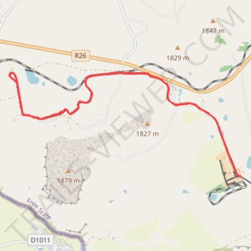
- Distance: 11.6 mi
- Elevation gain: 162 m
- Maximum elevation: 1,691 m
- Elevation loss: 158 m
- Minimum elevation: 1,649 m
- Moving time: 1 h 11 m
- Moving speed: 9.7 mph
- Maximum speed: 16.5 mph
- Total time: 1 h 23 m
- Global speed: 8.4 mph
Interactive trail map
Make a donation
Gear up for your next adventure:
As an Amazon Associate, this site earns from qualifying purchases at no extra cost to you.
Trail profile
- Distance: 11.6 mi
- Elevation gain: 162 m
- Maximum elevation: 1,691 m
- Elevation loss: 158 m
- Minimum elevation: 1,649 m
- Moving time: 1 h 11 m
- Moving speed: 9.7 mph
- Maximum speed: 16.5 mph
- Total time: 1 h 23 m
- Global speed: 8.4 mph
Make a donation
Gear up for your next adventure:
As an Amazon Associate, this site earns from qualifying purchases at no extra cost to you.
About this trail
Name: Sandstone line including new section built in the last few years trail, distance, elevation, map, profile, GPS track
Coordinates: -28.84584 27.94336 -28.82180 28.00408
Make a donation
Gear up for your next adventure:
As an Amazon Associate, this site earns from qualifying purchases at no extra cost to you.
Other hiking, mountain biking, running and outdoor activity trails
Click on a trail to view its statistics, map and profile.
Train Sandstone Estates
South Africa > Free State > Thabo Mofutsanyana District Municipality > Setsoto Local Municipality > Malutizicht
Distance: 2.7 mi • Elevation gain: 50 m • Maximum elevation: 1,665 m