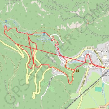
Circuit-de-clairefontaine
- Distance: 5.0 mi
- Elevation gain: 596 m
- Maximum elevation: 565 m
- Elevation loss: 362 m
- Minimum elevation: 270 m
Interactive trail map
Trail profile
- Distance: 5.0 mi
- Elevation gain: 596 m
- Maximum elevation: 565 m
- Elevation loss: 362 m
- Minimum elevation: 270 m
About this trail
Name: Circuit-de-clairefontaine trail, distance, elevation, map, profile, GPS track
Coordinates: 45.84546 5.62941 45.85446 5.65208
Other hiking, mountain biking, running and outdoor activity trails
Click on a trail to view its statistics, map and profile.
PT23DS2 Lörrach → Cadaqués
Germany > Baden-Württemberg > Landkreis Lörrach > Lörrach (Kernstadt)
Distance: 652.9 mi • Elevation gain: 13,130 m • Maximum elevation: 1,505 m
Chemin de Saint-Jacques-de-Compostelle
Switzerland > Geneva > Geneva
Distance: 694.6 mi • Elevation gain: 25,262 m • Maximum elevation: 1,430 m