Ligurische Grenzkammstraße (Nord)
- Distance: 21.1 mi
- Elevation gain: 1,384 m
- Maximum elevation: 2,242 m
- Elevation loss: 1,449 m
- Minimum elevation: 1,811 m
Interactive trail map
Trail profile
- Distance: 21.1 mi
- Elevation gain: 1,384 m
- Maximum elevation: 2,242 m
- Elevation loss: 1,449 m
- Minimum elevation: 1,811 m
About this trail
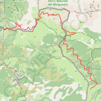
Name: Ligurische Grenzkammstraße (Nord) trail, distance, elevation, map, profile, GPS track
End: Strada Ex-Militare Monesi - Col di Tenda, Briga Alta, Cuneo, Piedmont, Italy (44.07677 7.72087)
Coordinates: 44.07677 7.56993 44.17387 7.73287
Other hiking, mountain biking, running and outdoor activity trails
Click on a trail to view its statistics, map and profile.
1 LUCENA - MONTPELLIER
Distance: 1,842.0 mi • Elevation gain: 29,500 m • Maximum elevation: 1,048 m
PT23DS2 Lörrach → Cadaqués
Germany > Baden-Württemberg > Landkreis Lörrach > Lörrach (Kernstadt)
Distance: 652.9 mi • Elevation gain: 13,130 m • Maximum elevation: 1,505 m