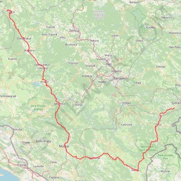
Track 143
8. 6. 2024 9:22 am
- Distance: 215.0 mi
- Elevation gain: 5,851 m
- Maximum elevation: 1,228 m
- Elevation loss: 5,922 m
- Minimum elevation: 44 m
Interactive trail map
Trail profile
- Distance: 215.0 mi
- Elevation gain: 5,851 m
- Maximum elevation: 1,228 m
- Elevation loss: 5,922 m
- Minimum elevation: 44 m
About this trail
Name: Track 143 trail, distance, elevation, map, profile, GPS track
Coordinates: 43.15675 17.21973 44.35103 18.93810
Other hiking, mountain biking, running and outdoor activity trails
Click on a trail to view its statistics, map and profile.
Zelengora: 4 Jezera i Vrh Bregoč
Bosnia and Herzegovina > Republika Srpska
Distance: 15.1 mi • Elevation gain: 892 m • Maximum elevation: 1,987 m
2022_Yu
Slovenia > Ajdovščina > Žapuže
Distance: 1,526.9 mi • Elevation gain: 32,048 m • Maximum elevation: 1,950 m
Zelengora - Bregoc - Kozije strane - Stog
Bosnia and Herzegovina > Republika Srpska
Distance: 7.8 mi • Elevation gain: 854 m • Maximum elevation: 2,000 m
Final_1dan1
Bosnia and Herzegovina > Federation of Bosnia and Herzegovina > Town of Konjic > Spiljani
This is track no: 4
Distance: 29.3 mi • Elevation gain: 2,206 m • Maximum elevation: 1,589 m