Zelengora: 4 Jezera i Vrh Bregoč
- Distance: 15.1 mi
- Elevation gain: 892 m
- Maximum elevation: 1,987 m
- Elevation loss: 892 m
- Minimum elevation: 1,470 m
- Moving time: 8 h 6 m
- Moving speed: 1.9 mph
- Maximum speed: 6.3 mph
- Total time: 12 h 52 m
- Global speed: 1.2 mph
Interactive trail map
Trail profile
- Distance: 15.1 mi
- Elevation gain: 892 m
- Maximum elevation: 1,987 m
- Elevation loss: 892 m
- Minimum elevation: 1,470 m
- Moving time: 8 h 6 m
- Moving speed: 1.9 mph
- Maximum speed: 6.3 mph
- Total time: 12 h 52 m
- Global speed: 1.2 mph
About this trail
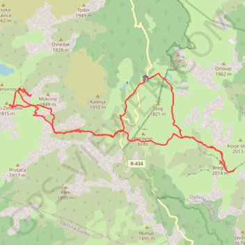
Name: Zelengora: 4 Jezera i Vrh Bregoč trail, distance, elevation, map, profile, GPS track
Coordinates: 43.35164 18.49007 43.37837 18.57369
Other hiking, mountain biking, running and outdoor activity trails
Click on a trail to view its statistics, map and profile.
2022_Yu
Slovenia > Ajdovščina > Žapuže
Distance: 1,526.9 mi • Elevation gain: 32,048 m • Maximum elevation: 1,950 m
Track 143
Bosnia and Herzegovina > Federation of Bosnia and Herzegovina > Ćusine > Donje Mile
8. 6. 2024 9:22 am
Distance: 215.0 mi • Elevation gain: 5,851 m • Maximum elevation: 1,228 m
Zelengora - Bregoc - Kozije strane - Stog
Bosnia and Herzegovina > Republika Srpska
Distance: 7.8 mi • Elevation gain: 854 m • Maximum elevation: 2,000 m