Thank you for supporting this site ❤️
Make a donation
Make a donation
Gear up for your next adventure:
As an Amazon Associate, this site earns from qualifying purchases at no extra cost to you.
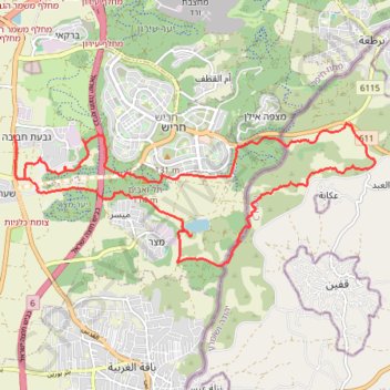
מסלול חדש ומטורף חוץ מקטע אחד
- Distance: 14.4 mi
- Elevation gain: 345 m
- Maximum elevation: 183 m
- Elevation loss: 345 m
- Minimum elevation: 35 m
- Moving time: 3 h 18 m
- Moving speed: 4.4 mph
- Maximum speed: 12.4 mph
- Total time: 3 h 44 m
- Global speed: 3.9 mph
Interactive trail map
Thank you for supporting this site ❤️
Make a donation
Make a donation
Gear up for your next adventure:
As an Amazon Associate, this site earns from qualifying purchases at no extra cost to you.
Trail profile
- Distance: 14.4 mi
- Elevation gain: 345 m
- Maximum elevation: 183 m
- Elevation loss: 345 m
- Minimum elevation: 35 m
- Moving time: 3 h 18 m
- Moving speed: 4.4 mph
- Maximum speed: 12.4 mph
- Total time: 3 h 44 m
- Global speed: 3.9 mph
Thank you for supporting this site ❤️
Make a donation
Make a donation
Gear up for your next adventure:
As an Amazon Associate, this site earns from qualifying purchases at no extra cost to you.
About this trail
Name: מסלול חדש ומטורף חוץ מקטע אחד trail, distance, elevation, map, profile, GPS track
Coordinates: 32.43644 35.01955 32.46023 35.09093
Thank you for supporting this site ❤️
Make a donation
Make a donation
Gear up for your next adventure:
As an Amazon Associate, this site earns from qualifying purchases at no extra cost to you.