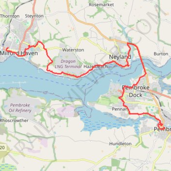
Pembroke to Milford Haven on Wales Coast Path (WCP)
- Distance: 12.8 mi
- Elevation gain: 458 m
- Maximum elevation: 58 m
- Elevation loss: 434 m
- Minimum elevation: 0 m
- Moving time: 5 h 3 m
- Moving speed: 2.5 mph
- Maximum speed: 13.6 mph
- Total time: 5 h 38 m
- Global speed: 2.3 mph
Interactive trail map
Trail profile
- Distance: 12.8 mi
- Elevation gain: 458 m
- Maximum elevation: 58 m
- Elevation loss: 434 m
- Minimum elevation: 0 m
- Moving time: 5 h 3 m
- Moving speed: 2.5 mph
- Maximum speed: 13.6 mph
- Total time: 5 h 38 m
- Global speed: 2.3 mph
About this trail
Name: Pembroke to Milford Haven on Wales Coast Path (WCP) trail, distance, elevation, map, profile, GPS track
Coordinates: 51.67501 -5.03868 51.71713 -4.91667
Topography: Pembrokeshire topographic map, elevation, terrain
Other hiking, mountain biking, running and outdoor activity trails
Click on a trail to view its statistics, map and profile.
Angle to Pembroke - Wales Coast Path (WCP)
United Kingdom > Wales > Pembrokeshire > Angle
Distance: 11.5 mi • Elevation gain: 308 m • Maximum elevation: 63 m