Cobble Hill Mountain Regional Recreation Area
#Hiking #Loop #CobbleHill
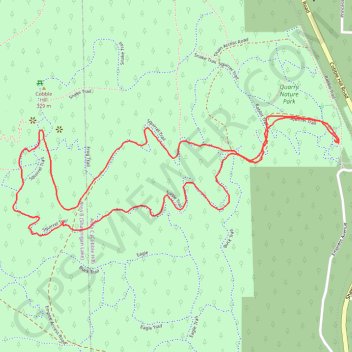
- Distance: 2.2 mi
- Elevation gain: 223 m
- Maximum elevation: 314 m
- Elevation loss: 223 m
- Minimum elevation: 101 m
Interactive trail map
Trail profile
- Distance: 2.2 mi
- Elevation gain: 223 m
- Maximum elevation: 314 m
- Elevation loss: 223 m
- Minimum elevation: 101 m
About this trail
Name: Cobble Hill Mountain Regional Recreation Area trail, distance, elevation, map, profile, GPS track
Coordinates: 48.68452 -123.61895 48.68785 -123.60524
Other hiking, mountain biking, running and outdoor activity trails
Click on a trail to view its statistics, map and profile.
Cobble Hill Loop
Canada > British Columbia > Cowichan Valley Regional District > Area C (Cobble Hill) > Cobble Hill
Cobble Hill Mountain Regional Recreation Area. #Hiking #MTB #Loop #CobbleHill
Distance: 4.5 mi • Elevation gain: 325 m • Maximum elevation: 320 m
BBF loop to the Skydeck in Nanaimo
Canada > British Columbia > Cowichan Valley Regional District > Area A (Mill Bay / Malahat) > Mill Bay
BBF loop to the Skydeck
Distance: 201.0 mi • Elevation gain: 6,222 m • Maximum elevation: 706 m