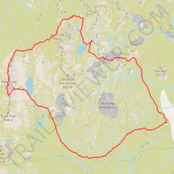
Dow Crag via South Rake
- Distance: 6.0 mi
- Elevation gain: 770 m
- Maximum elevation: 796 m
- Elevation loss: 770 m
- Minimum elevation: 225 m
- Moving time: 3 h 12 m
- Moving speed: 1.9 mph
- Maximum speed: 3.7 mph
- Total time: 6 h 53 m
- Global speed: 0.9 mph
Interactive trail map
Trail profile
- Distance: 6.0 mi
- Elevation gain: 770 m
- Maximum elevation: 796 m
- Elevation loss: 770 m
- Minimum elevation: 225 m
- Moving time: 3 h 12 m
- Moving speed: 1.9 mph
- Maximum speed: 3.7 mph
- Total time: 6 h 53 m
- Global speed: 0.9 mph
About this trail
Name: Dow Crag via South Rake trail, distance, elevation, map, profile, GPS track
Coordinates: 54.35819 -3.13724 54.37966 -3.09575
Topography: Westmorland and Furness topographic map, elevation, terrain
Other hiking, mountain biking, running and outdoor activity trails
Click on a trail to view its statistics, map and profile.
Sun Coniston to Great Langdale
United Kingdom > England > Westmorland and Furness > Coniston
Distance: 9.1 mi • Elevation gain: 999 m • Maximum elevation: 796 m