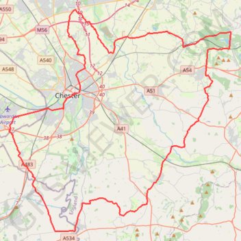
Bike Loop from Chester
#Bike #Loop #Road #Countryside #Nature
- Distance: 51.4 mi
- Elevation gain: 532 m
- Maximum elevation: 163 m
- Elevation loss: 533 m
- Minimum elevation: 6 m
Interactive trail map
Trail profile
- Distance: 51.4 mi
- Elevation gain: 532 m
- Maximum elevation: 163 m
- Elevation loss: 533 m
- Minimum elevation: 6 m
About this trail
Name: Bike Loop from Chester trail, distance, elevation, map, profile, GPS track
Coordinates: 53.07887 -2.97092 53.26081 -2.66587
Topography: Chester topographic map, elevation, terrain
Other hiking, mountain biking, running and outdoor activity trails
Click on a trail to view its statistics, map and profile.
The Port
United Kingdom > Wales > Flintshire > Connah's Quay
Distance: 23.5 mi • Elevation gain: 191 m • Maximum elevation: 71 m