Sea to Summit: Spencer Gulf - Flinders Ranges - Melrose
Mount Remarkable National Park. #Hiking #Running #SeaToSummit #Remarkable
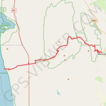
- Distance: 26.5 mi
- Elevation gain: 1,462 m
- Maximum elevation: 950 m
- Elevation loss: 1,079 m
- Minimum elevation: 0 m
Interactive trail map
Trail profile
- Distance: 26.5 mi
- Elevation gain: 1,462 m
- Maximum elevation: 950 m
- Elevation loss: 1,079 m
- Minimum elevation: 0 m
About this trail
Name: Sea to Summit: Spencer Gulf - Flinders Ranges - Melrose trail, distance, elevation, map, profile, GPS track
Coordinates: -32.86278 137.91309 -32.78594 138.18634
Other hiking, mountain biking, running and outdoor activity trails
Click on a trail to view its statistics, map and profile.
Mount Remarkable Epic MTB trail trace
Australia > South Australia > Melrose
2 x Laps of Melrose Epic on the single speed
Distance: 49.6 mi • Elevation gain: 2,980 m • Maximum elevation: 947 m
Mount Remarkable North Face
Australia > South Australia > Melrose
Morning Mountain Bike Ride
Distance: 29.0 mi • Elevation gain: 1,370 m • Maximum elevation: 842 m