Thank you for supporting this site ❤️
Make a donation
Make a donation
Gear up for your next adventure:
As an Amazon Associate, this site earns from qualifying purchases at no extra cost to you.
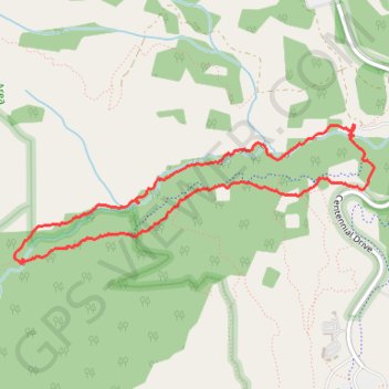
Ribbon Creek Loop
Evan-Thomas Provincial Recreation Area. Spray Valley Provincial Park. #Hiking #Loop #EvanThomas #SprayValley
- Distance: 3.5 mi
- Elevation gain: 154 m
- Maximum elevation: 1,589 m
- Elevation loss: 154 m
- Minimum elevation: 1,467 m
Interactive trail map
Thank you for supporting this site ❤️
Make a donation
Make a donation
Gear up for your next adventure:
As an Amazon Associate, this site earns from qualifying purchases at no extra cost to you.
Trail profile
- Distance: 3.5 mi
- Elevation gain: 154 m
- Maximum elevation: 1,589 m
- Elevation loss: 154 m
- Minimum elevation: 1,467 m
Thank you for supporting this site ❤️
Make a donation
Make a donation
Gear up for your next adventure:
As an Amazon Associate, this site earns from qualifying purchases at no extra cost to you.
About this trail
Name: Ribbon Creek Loop trail, distance, elevation, map, profile, GPS track
Coordinates: 50.92570 -115.17713 50.93320 -115.14651
Thank you for supporting this site ❤️
Make a donation
Make a donation
Gear up for your next adventure:
As an Amazon Associate, this site earns from qualifying purchases at no extra cost to you.
Other hiking, mountain biking, running and outdoor activity trails
Click on a trail to view its statistics, map and profile.