Wedeln Run - Lowland Trail
Spencer Gorge Conservation Area. Christie Reservoir. #Hiking #Loop #SpencerGorge
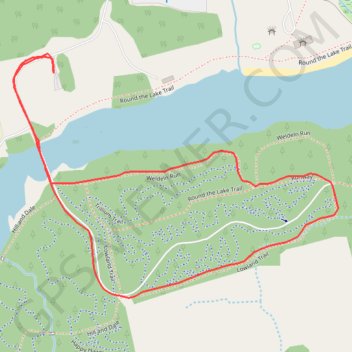
- Distance: 1.8 mi
- Elevation gain: 31 m
- Maximum elevation: 261 m
- Elevation loss: 31 m
- Minimum elevation: 235 m
Interactive trail map
Trail profile
- Distance: 1.8 mi
- Elevation gain: 31 m
- Maximum elevation: 261 m
- Elevation loss: 31 m
- Minimum elevation: 235 m
About this trail
Name: Wedeln Run - Lowland Trail trail, distance, elevation, map, profile, GPS track
Start: Round the Lake Trail, Hamilton, Golden Horseshoe, Ontario, L9H 5E2, Canada (43.28071 -80.03174)
End: Round the Lake Trail, Hamilton, Golden Horseshoe, Ontario, L9H 5E2, Canada (43.28071 -80.03174)
Coordinates: 43.27521 -80.03306 43.28109 -80.02229
Other hiking, mountain biking, running and outdoor activity trails
Click on a trail to view its statistics, map and profile.
Aldershot - Kitchener
Canada > Ontario > Halton Region > Burlington
#Bike
Distance: 49.1 mi • Elevation gain: 570 m • Maximum elevation: 346 m