
Santa Catalina Island
Interactive trail map
Trail profile
- Distance: 7.6 mi
- Elevation gain: 531 m
- Maximum elevation: 73 m
- Elevation loss: 520 m
- Minimum elevation: 0 m
About this trail
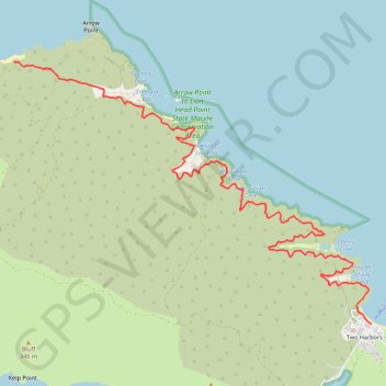
Name: Santa Catalina Island trail, distance, elevation, map, profile, GPS track
Start: Isthmus Road, Two Harbors, Los Angeles County, California, United States (33.44154 -118.49821)
End: West End Road, Los Angeles County, California, United States (33.47277 -118.54927)
Coordinates: 33.44154 -118.54927 33.47277 -118.49821
Other hiking, mountain biking, running and outdoor activity trails
Click on a trail to view its statistics, map and profile.
Trans Catalina Trail (TCT)
United States > California > Los Angeles County > Avalon > Pebbly Beach
The Trans-Catalina Trail begins in Avalon, leaving the island’s lively harbor town to climb into the dry, rugged interior of Santa Catalina Island. The route passes Haypress Reservoir and Cape Canyon Reservoir before entering the Black Jack backcountry and continuing toward Catalina Airport, often known as…
Distance: 38.7 mi • Elevation gain: 2,826 m • Maximum elevation: 531 m