Import a GPX file

Los Peñasquitos Waterfall

Hike to Los Peñasquitos Waterfall through Los Peñasquitos Canyon Preserve. #Hiking #Fall #River #Nature #Forest #Park

  • Distance: 3.3 mi
  • Elevation gain: 19 m
  • Maximum elevation: 77 m
  • Elevation loss: 48 m
  • Minimum elevation: 47 m

Interactive trail map

Trail profile

  • Distance: 3.3 mi
  • Elevation gain: 19 m
  • Maximum elevation: 77 m
  • Elevation loss: 48 m
  • Minimum elevation: 47 m

About this trail

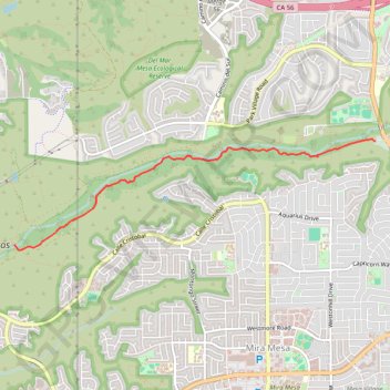
Name: Los Peñasquitos Waterfall trail, distance, elevation, map, profile, GPS track

Start: San Diego Sea to Sea Trail, San Diego, San Diego County, California, 92129, United States (32.93846 -117.12974)

End: North Side Trail, San Diego, San Diego County, California, 92126, United States (32.92700 -117.17728)

Coordinates: 32.92639 -117.17728 32.93866 -117.12974

Gear up for your next adventure:

🎒Hiking Child Carriers - Explore the outdoors with the whole family safely
🦯Walking Poles - Supportive poles for long-distance walking
🛰️Satellite Messengers - Emergency communication devices for areas without mobile signal
🔥Emergency Fire Starters - Reliable ignition tools for survival situations in damp conditions
🥾Hiking Boot Waterproofing Wax - Maintain the lifespan of your leather trekking boots

As an Amazon Associate, this site earns from qualifying purchases at no extra cost to you.