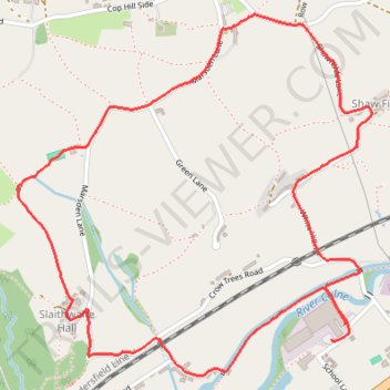
Slaithwaite Hall and Rose and Crown
- Distance: 2.6 mi
- Elevation gain: 145 m
- Maximum elevation: 302 m
- Elevation loss: 146 m
- Minimum elevation: 155 m
- Moving time: 1 h 34 m
- Moving speed: 1.6 mph
- Maximum speed: 2.7 mph
- Total time: 2 h 5 m
- Global speed: 1.2 mph
Interactive trail map
Trail profile
- Distance: 2.6 mi
- Elevation gain: 145 m
- Maximum elevation: 302 m
- Elevation loss: 146 m
- Minimum elevation: 155 m
- Moving time: 1 h 34 m
- Moving speed: 1.6 mph
- Maximum speed: 2.7 mph
- Total time: 2 h 5 m
- Global speed: 1.2 mph
About this trail
Name: Slaithwaite Hall and Rose and Crown trail, distance, elevation, map, profile, GPS track
Coordinates: 53.61197 -1.91960 53.62130 -1.90418
Topography: Kirklees topographic map, elevation, terrain
Other hiking, mountain biking, running and outdoor activity trails
Click on a trail to view its statistics, map and profile.
Marsden Slaithwaite road blackberrys - Huddersfield Narrow Canal - River Colne
United Kingdom > England > Kirklees > Marsden > Dirker
Distance: 3.5 mi • Elevation gain: 102 m • Maximum elevation: 218 m
Marsden Netherwoods and Zapatos
United Kingdom > England > Kirklees > Marsden > Woods
Distance: 4.1 mi • Elevation gain: 157 m • Maximum elevation: 278 m
Marsden Lanes out & canal back
United Kingdom > England > Kirklees > Marsden > Dirker
Distance: 2.9 mi • Elevation gain: 73 m • Maximum elevation: 200 m
Marsden - Lower catch to Slaithwaite
United Kingdom > England > Kirklees > Marsden > Woods
Distance: 3.5 mi • Elevation gain: 126 m • Maximum elevation: 304 m