
The Precipice Trail and Champlain North Ridge Loop Trail
- Distance: 2.1 mi
- Elevation gain: 303 m
- Maximum elevation: 317 m
- Elevation loss: 335 m
- Minimum elevation: 30 m
- Moving time: 1 h 25 m
- Moving speed: 1.5 mph
- Maximum speed: 9.9 mph
- Total time: 2 h 50 m
- Global speed: 0.7 mph
Interactive trail map
Trail profile
- Distance: 2.1 mi
- Elevation gain: 303 m
- Maximum elevation: 317 m
- Elevation loss: 335 m
- Minimum elevation: 30 m
- Moving time: 1 h 25 m
- Moving speed: 1.5 mph
- Maximum speed: 9.9 mph
- Total time: 2 h 50 m
- Global speed: 0.7 mph
About this trail
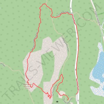
Name: The Precipice Trail and Champlain North Ridge Loop Trail trail, distance, elevation, map, profile, GPS track
Start: The Precipice Trail, Bar Harbor, Hancock County, Maine, United States (44.34923 -68.18906)
End: Park Loop Road, Bar Harbor, Hancock County, Maine, United States (44.34972 -68.18800)
Coordinates: 44.34923 -68.19429 44.35777 -68.18772
Other hiking, mountain biking, running and outdoor activity trails
Click on a trail to view its statistics, map and profile.
Precipice Loop via Champlain Mountain in Acadia National Park
United States > Maine > Hancock County > Bar Harbor
The Precipice Loop is a highly challenging and adventurous hike, renowned for its steep, exposed cliffs and iron rungs that assist hikers in ascending the vertical face of Champlain Mountain. The climb offers dramatic views of Frenchman Bay and the surrounding landscapes, but it demands both physical stamina…
Distance: 2.8 mi • Elevation gain: 359 m • Maximum elevation: 317 m

The Precipice Loop via Champlain North Ridge Trail and Schooner Head Path
United States > Maine > Hancock County > Bar Harbor
The Precipice Loop offers a thrilling yet challenging hiking experience in Acadia National Park. Hikers will enjoy sweeping views over Frenchman Bay and the surrounding coastline, with sections of the trail providing dramatic cliffside scrambles, iron rungs, and narrow ledges. As you ascend, the route unveils…
Distance: 2.8 mi • Elevation gain: 351 m • Maximum elevation: 317 m