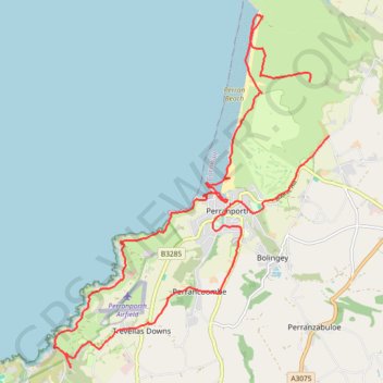
Around Perranporth
- Distance: 14.4 mi
- Elevation gain: 867 m
- Maximum elevation: 102 m
- Elevation loss: 844 m
- Minimum elevation: 0 m
- Moving time: 5 h 46 m
- Moving speed: 2.5 mph
- Maximum speed: 9.6 mph
- Total time: 6 h 50 m
- Global speed: 2.1 mph
Interactive trail map
Trail profile
- Distance: 14.4 mi
- Elevation gain: 867 m
- Maximum elevation: 102 m
- Elevation loss: 844 m
- Minimum elevation: 0 m
- Moving time: 5 h 46 m
- Moving speed: 2.5 mph
- Maximum speed: 9.6 mph
- Total time: 6 h 50 m
- Global speed: 2.1 mph
About this trail
Name: Around Perranporth trail, distance, elevation, map, profile, GPS track
End: Rose, Perranzabuloe, Cornwall, England, TR4 9PN, United Kingdom (50.35591 -5.12944)
Coordinates: 50.31993 -5.19603 50.37473 -5.12944
Topography: Cornwall topographic map, elevation, terrain
Other hiking, mountain biking, running and outdoor activity trails
Click on a trail to view its statistics, map and profile.
St Agnes
United Kingdom > England > Cornwall > St. Agnes
Distance: 7.1 mi • Elevation gain: 571 m • Maximum elevation: 144 m
Newquay to Penhale Sands
United Kingdom > England > Cornwall > Newquay
Distance: 18.0 mi • Elevation gain: 711 m • Maximum elevation: 88 m
Perranporth
United Kingdom > England > Cornwall > Goonhavern > Rosehill
Distance: 8.8 mi • Elevation gain: 569 m • Maximum elevation: 97 m