Thank you for supporting this site ❤️
Make a donation
Make a donation
Gear up for your next adventure:
As an Amazon Associate, this site earns from qualifying purchases at no extra cost to you.
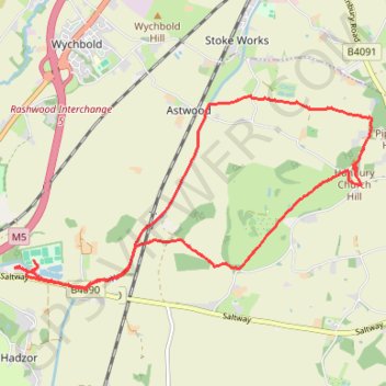
Hanbury Canal and Hanbury Church Hill walk
- Distance: 7.9 mi
- Elevation gain: 154 m
- Maximum elevation: 121 m
- Elevation loss: 155 m
- Minimum elevation: 38 m
- Moving time: 3 h 43 m
- Moving speed: 2.1 mph
- Maximum speed: 5.5 mph
- Total time: 5 h 20 m
- Global speed: 1.5 mph
Interactive trail map
Thank you for supporting this site ❤️
Make a donation
Make a donation
Gear up for your next adventure:
As an Amazon Associate, this site earns from qualifying purchases at no extra cost to you.
Trail profile
- Distance: 7.9 mi
- Elevation gain: 154 m
- Maximum elevation: 121 m
- Elevation loss: 155 m
- Minimum elevation: 38 m
- Moving time: 3 h 43 m
- Moving speed: 2.1 mph
- Maximum speed: 5.5 mph
- Total time: 5 h 20 m
- Global speed: 1.5 mph
Thank you for supporting this site ❤️
Make a donation
Make a donation
Gear up for your next adventure:
As an Amazon Associate, this site earns from qualifying purchases at no extra cost to you.
About this trail
Name: Hanbury Canal and Hanbury Church Hill walk trail, distance, elevation, map, profile, GPS track
Coordinates: 52.26466 -2.12719 52.28502 -2.06572
Topography: Wychavon topographic map, elevation, terrain
Thank you for supporting this site ❤️
Make a donation
Make a donation
Gear up for your next adventure:
As an Amazon Associate, this site earns from qualifying purchases at no extra cost to you.