Make a donation
Gear up for your next adventure:
As an Amazon Associate, this site earns from qualifying purchases at no extra cost to you.
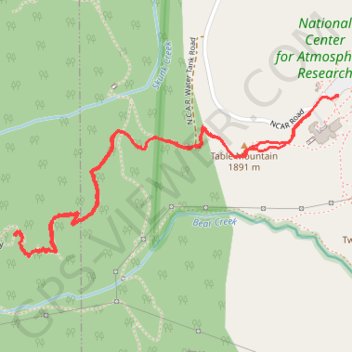
Mallory Cave Trail via NCAR Trail and Table Mountain
The Mallory Cave Trail via the NCAR and Table Mountain offers a rewarding hike through Boulder’s iconic foothills. Starting from the NCAR campus, the trail winds through open meadows, offering striking views of the Flatirons and red rock formations. The final section involves a challenging scramble up to the cave, which remains closed to protect local bat populations, but the panoramic scenery along the route makes the effort worthwhile. #Hiking #Mountain #Forest #Nature #Cave
- Distance: 2.8 mi
- Elevation gain: 284 m
- Maximum elevation: 2,080 m
- Elevation loss: 284 m
- Minimum elevation: 1,852 m
- Moving time: 1 h 29 m
- Moving speed: 1.9 mph
- Maximum speed: 3.7 mph
- Total time: 1 h 59 m
- Global speed: 1.4 mph
Interactive trail map
Make a donation
Gear up for your next adventure:
As an Amazon Associate, this site earns from qualifying purchases at no extra cost to you.
Trail profile
- Distance: 2.8 mi
- Elevation gain: 284 m
- Maximum elevation: 2,080 m
- Elevation loss: 284 m
- Minimum elevation: 1,852 m
- Moving time: 1 h 29 m
- Moving speed: 1.9 mph
- Maximum speed: 3.7 mph
- Total time: 1 h 59 m
- Global speed: 1.4 mph
Make a donation
Gear up for your next adventure:
As an Amazon Associate, this site earns from qualifying purchases at no extra cost to you.
About this trail
Name: Mallory Cave Trail via NCAR Trail and Table Mountain trail, distance, elevation, map, profile, GPS track
Start: NCAR Road, Boulder, Boulder County, Colorado, 80305, United States (39.97925 -105.27418)
End: NCAR Road, Boulder, Boulder County, Colorado, 80305, United States (39.97927 -105.27418)
Coordinates: 39.97355 -105.28924 39.97927 -105.27418
Make a donation
Gear up for your next adventure:
As an Amazon Associate, this site earns from qualifying purchases at no extra cost to you.