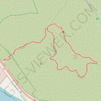
Mugu Peak Loop
Loop hike to Mugu Peak by the Chumash Trail and the Mugu Peak Trail in the La Jolla Valley Natural Preserve and the Point Mugu State Park. #Hiking #Loop #Mountain #Nature #Park #Sea #Pacific #Ocean
- Distance: 2.8 mi
- Elevation gain: 440 m
- Maximum elevation: 384 m
- Elevation loss: 440 m
- Minimum elevation: 10 m
Interactive trail map
Trail profile
- Distance: 2.8 mi
- Elevation gain: 440 m
- Maximum elevation: 384 m
- Elevation loss: 440 m
- Minimum elevation: 10 m
About this trail
Name: Mugu Peak Loop trail, distance, elevation, map, profile, GPS track
Start: Pacific Coast Highway, Ventura County, California, United States (34.09179 -119.06557)
End: Chumash Trail, Ventura County, California, United States (34.09176 -119.06556)
Coordinates: 34.08979 -119.06557 34.09628 -119.05180