Wild Bank
Tameside Hiking
- Distance: 6.8 mi
- Elevation gain: 303 m
- Maximum elevation: 398 m
- Elevation loss: 303 m
- Minimum elevation: 187 m
- Moving time: 2 h 51 m
- Moving speed: 2.4 mph
- Maximum speed: 4.8 mph
- Total time: 3 h 51 m
- Global speed: 1.8 mph
Interactive trail map
Trail profile
- Distance: 6.8 mi
- Elevation gain: 303 m
- Maximum elevation: 398 m
- Elevation loss: 303 m
- Minimum elevation: 187 m
- Moving time: 2 h 51 m
- Moving speed: 2.4 mph
- Maximum speed: 4.8 mph
- Total time: 3 h 51 m
- Global speed: 1.8 mph
About this trail
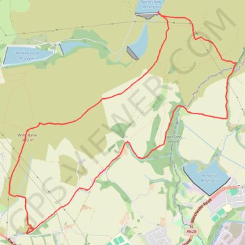
Name: Wild Bank trail, distance, elevation, map, profile, GPS track
Coordinates: 53.46626 -2.02208 53.49309 -1.97599
Topography: Tameside topographic map, elevation, terrain
Other hiking, mountain biking, running and outdoor activity trails
Click on a trail to view its statistics, map and profile.
Wild Bank - Higher Swineshaw Reservoir - Swallows Wood - Loop
United Kingdom > England > Tameside > Mottram > Stalyhill
Distance: 6.8 mi • Elevation gain: 311 m • Maximum elevation: 398 m