Import a GPX file

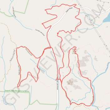
Dupont Forest MTB Loops

Mountain Bike in Dupont State Recreation Forest via Cedar Rock and Little River. #MTB #Loop #Forest #Mountain #River #Nature

  • Distance: 9.5 mi
  • Elevation gain: 354 m
  • Maximum elevation: 930 m
  • Elevation loss: 354 m
  • Minimum elevation: 805 m

Interactive trail map

Trail profile

  • Distance: 9.5 mi
  • Elevation gain: 354 m
  • Maximum elevation: 930 m
  • Elevation loss: 354 m
  • Minimum elevation: 805 m

About this trail

Gear up for your next adventure:

🔥Reusable Hand Warmers - Maintain dexterity in your fingers for precise map handling
🧴Sport Sunscreen Sticks - High-protection sunblock that won't run into your eyes on the trail
🔋Rechargeable Batteries - Eco-friendly power for headlamps and older GPS units
🗺️Ordnance Survey Maps - Official UK maps for walking and outdoor activities
🧺Ultralight Dry Bags - Organize and waterproof your gear inside your rucksack

As an Amazon Associate, this site earns from qualifying purchases at no extra cost to you.