Thank you for supporting this site ❤️
Make a donation
Make a donation
Gear up for your next adventure:
As an Amazon Associate, this site earns from qualifying purchases at no extra cost to you.
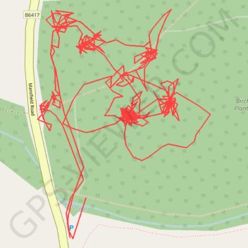
RE SK490680
- Distance: 2.0 mi
- Elevation gain: 31 m
- Maximum elevation: 164 m
- Elevation loss: 32 m
- Minimum elevation: 154 m
- Moving time: 1 h 28 m
- Moving speed: 1.4 mph
- Maximum speed: 10.3 mph
- Total time: 4 h 23 m
- Global speed: 0.5 mph
Interactive trail map
Thank you for supporting this site ❤️
Make a donation
Make a donation
Gear up for your next adventure:
As an Amazon Associate, this site earns from qualifying purchases at no extra cost to you.
Trail profile
- Distance: 2.0 mi
- Elevation gain: 31 m
- Maximum elevation: 164 m
- Elevation loss: 32 m
- Minimum elevation: 154 m
- Moving time: 1 h 28 m
- Moving speed: 1.4 mph
- Maximum speed: 10.3 mph
- Total time: 4 h 23 m
- Global speed: 0.5 mph
Thank you for supporting this site ❤️
Make a donation
Make a donation
Gear up for your next adventure:
As an Amazon Associate, this site earns from qualifying purchases at no extra cost to you.
About this trail
Name: RE SK490680 trail, distance, elevation, map, profile, GPS track
Coordinates: 53.20588 -1.26801 53.20767 -1.26576
Topography: Derbyshire topographic map, elevation, terrain
Thank you for supporting this site ❤️
Make a donation
Make a donation
Gear up for your next adventure:
As an Amazon Associate, this site earns from qualifying purchases at no extra cost to you.
Other hiking, mountain biking, running and outdoor activity trails
Click on a trail to view its statistics, map and profile.
Heath to Bolsover
United Kingdom > England > Derbyshire > North East Derbyshire > Heath
Distance: 8.4 mi • Elevation gain: 170 m • Maximum elevation: 181 m