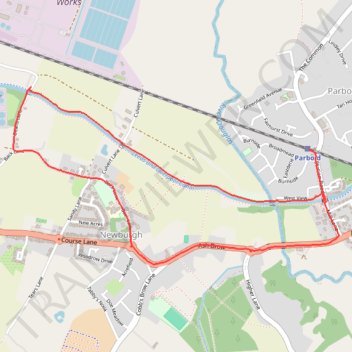
Newburgh
- Distance: 2.6 mi
- Elevation gain: 30 m
- Maximum elevation: 34 m
- Elevation loss: 26 m
- Minimum elevation: 13 m
- Moving time: 55 m 35 s
- Moving speed: 2.8 mph
- Maximum speed: 3.9 mph
- Total time: 58 m 41 s
- Global speed: 2.6 mph
Interactive trail map
Trail profile
- Distance: 2.6 mi
- Elevation gain: 30 m
- Maximum elevation: 34 m
- Elevation loss: 26 m
- Minimum elevation: 13 m
- Moving time: 55 m 35 s
- Moving speed: 2.8 mph
- Maximum speed: 3.9 mph
- Total time: 58 m 41 s
- Global speed: 2.6 mph
About this trail
Name: Newburgh trail, distance, elevation, map, profile, GPS track
Coordinates: 53.58607 -2.79165 53.59340 -2.76895
Topography: West Lancashire topographic map, elevation, terrain
Other hiking, mountain biking, running and outdoor activity trails
Click on a trail to view its statistics, map and profile.
Leeds-Liverpool Canal, Parbold to Burscough Bridge
United Kingdom > England > Lancashire > West Lancashire > Parbold
Distance: 4.8 mi • Elevation gain: 29 m • Maximum elevation: 23 m
Parbold - Leeds and Liverpool Canal Loop Walk
United Kingdom > England > Lancashire > West Lancashire > Parbold
Distance: 3.3 mi • Elevation gain: 61 m • Maximum elevation: 50 m
Leeds and Liverpool Canal between Parbold and Appley Bridge
United Kingdom > England > Lancashire > West Lancashire > Parbold
Distance: 2.8 mi • Elevation gain: 36 m • Maximum elevation: 34 m
Parbold - Newburgh - Leeds and Liverpool Canal
United Kingdom > England > Lancashire > West Lancashire > Newburgh
Distance: 2.4 mi • Elevation gain: 39 m • Maximum elevation: 34 m
Parbold - Leeds and Liverpool Canal
United Kingdom > England > Lancashire > West Lancashire > Parbold
Distance: 2.4 mi • Elevation gain: 30 m • Maximum elevation: 35 m
Newburgh Parbold loop
United Kingdom > England > Lancashire > West Lancashire > Newburgh
West Lancashire Walk
Distance: 2.4 mi • Elevation gain: 27 m • Maximum elevation: 34 m