Lynn Peak route fast hike / run
- Distance: 6.2 mi
- Elevation gain: 752 m
- Maximum elevation: 936 m
- Elevation loss: 756 m
- Minimum elevation: 203 m
- Moving time: 2 h 21 m
- Moving speed: 2.7 mph
- Maximum speed: 7.9 mph
- Total time: 2 h 30 m
- Global speed: 2.5 mph
Interactive trail map
Trail profile
- Distance: 6.2 mi
- Elevation gain: 752 m
- Maximum elevation: 936 m
- Elevation loss: 756 m
- Minimum elevation: 203 m
- Moving time: 2 h 21 m
- Moving speed: 2.7 mph
- Maximum speed: 7.9 mph
- Total time: 2 h 30 m
- Global speed: 2.5 mph
About this trail
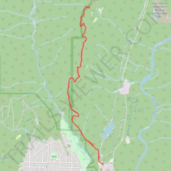
Name: Lynn Peak route fast hike / run trail, distance, elevation, map, profile, GPS track
Coordinates: 49.35023 -123.02594 49.38187 -123.01493
Other hiking, mountain biking, running and outdoor activity trails
Click on a trail to view its statistics, map and profile.
Lynn Loop Trail - Headwaters Trail
Canada > British Columbia > Metro Vancouver Regional District
Lynn Headwaters Regional Park. #Hiking #Loop #LynnHeadwaters
Distance: 8.9 mi • Elevation gain: 424 m • Maximum elevation: 424 m
Lower Lynn Loop Trail
Canada > British Columbia > Metro Vancouver Regional District
Lynn Headwaters Regional Park. #Hiking #Loop #LynnHeadwaters
Distance: 3.5 mi • Elevation gain: 250 m • Maximum elevation: 376 m