Shady to Lightning Ridge
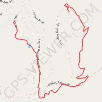
Mt Laguna and Horse Heaven CG areas, including Lightning Ridge Trail
- Distance: 1.3 mi
- Elevation gain: 92 m
- Maximum elevation: 1,758 m
- Elevation loss: 16 m
- Minimum elevation: 1,679 m
- Moving time: 29 m 55 s
- Moving speed: 2.6 mph
- Maximum speed: 4.7 mph
- Total time: 31 m 35 s
- Global speed: 2.5 mph
Interactive trail map
Trail profile
- Distance: 1.3 mi
- Elevation gain: 92 m
- Maximum elevation: 1,758 m
- Elevation loss: 16 m
- Minimum elevation: 1,679 m
- Moving time: 29 m 55 s
- Moving speed: 2.6 mph
- Maximum speed: 4.7 mph
- Total time: 31 m 35 s
- Global speed: 2.5 mph
About this trail
Name: Shady to Lightning Ridge trail, distance, elevation, map, profile, GPS track
Start: Shady Loop, San Diego County, California, 91948, United States (32.88859 -116.44953)
End: Lightning Ridge Trail, San Diego County, California, 91948, United States (32.88917 -116.44533)
Coordinates: 32.88361 -116.44960 32.88967 -116.44386
Other hiking, mountain biking, running and outdoor activity trails
Click on a trail to view its statistics, map and profile.
Big Laguna Meadow Sunset Trail Loop
United States > California > San Diego County
Two trails around Mount Laguna Campground
Distance: 8.8 mi • Elevation gain: 311 m • Maximum elevation: 1,749 m
Epic Big Laguna Route
United States > California > San Diego County
Distance: 9.2 mi • Elevation gain: 342 m • Maximum elevation: 1,891 m