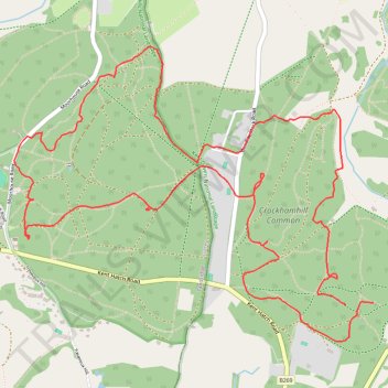
High Chart and Limpsfield National & SE League
- Distance: 5.5 mi
- Elevation gain: 146 m
- Maximum elevation: 214 m
- Elevation loss: 149 m
- Minimum elevation: 136 m
- Moving time: 1 h 43 m
- Moving speed: 3.2 mph
- Maximum speed: 10.3 mph
- Total time: 1 h 47 m
- Global speed: 3.1 mph
Interactive trail map
Trail profile
- Distance: 5.5 mi
- Elevation gain: 146 m
- Maximum elevation: 214 m
- Elevation loss: 149 m
- Minimum elevation: 136 m
- Moving time: 1 h 43 m
- Moving speed: 3.2 mph
- Maximum speed: 10.3 mph
- Total time: 1 h 47 m
- Global speed: 3.1 mph
About this trail
Name: High Chart and Limpsfield National & SE League trail, distance, elevation, map, profile, GPS track
Coordinates: 51.24266 0.04285 51.25700 0.07072
Topography: Kent topographic map, elevation, terrain