Annapolis Rock via Appalachian Trail in South Mountain State Park
The Annapolis Rock Trail, accessible via the Appalachian Trail in South Mountain State Park, offers hikers a rewarding journey through diverse landscapes. The initial ascent is steep, but the path becomes more moderate as you approach the summit. The path meanders through dense forests, providing a serene woodland experience. Upon reaching Annapolis Rock, hikers are treated to expansive vistas of the surrounding valleys and distant ridgelines, making it a popular spot for both day hikers and backpackers. #Hiking #Mountain #Forest #Nature #Overlook
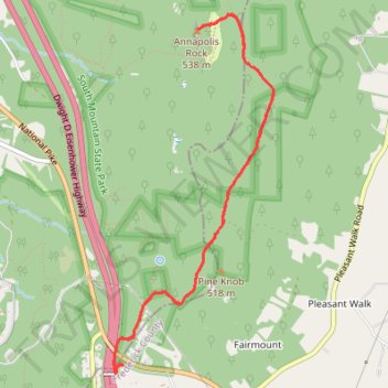
- Distance: 4.9 mi
- Elevation gain: 267 m
- Maximum elevation: 538 m
- Elevation loss: 267 m
- Minimum elevation: 370 m
- Moving time: 1 h 42 m
- Moving speed: 2.8 mph
- Maximum speed: 4.9 mph
- Total time: 1 h 56 m
- Global speed: 2.5 mph
Interactive trail map
Trail profile
- Distance: 4.9 mi
- Elevation gain: 267 m
- Maximum elevation: 538 m
- Elevation loss: 267 m
- Minimum elevation: 370 m
- Moving time: 1 h 42 m
- Moving speed: 2.8 mph
- Maximum speed: 4.9 mph
- Total time: 1 h 56 m
- Global speed: 2.5 mph
About this trail
Name: Annapolis Rock via Appalachian Trail in South Mountain State Park trail, distance, elevation, map, profile, GPS track
Coordinates: 39.53510 -77.60595 39.55946 -77.59186
Other hiking, mountain biking, running and outdoor activity trails
Click on a trail to view its statistics, map and profile.
Annapolis Rock via Appalachian Trail in South Mountain State Park
United States > Maryland > Frederick County > Wolfsville Crossing
The Annapolis Rock hike along the Appalachian Trail offers an invigorating climb through lush forest, with views of the surrounding valleys and mountains as you ascend. After passing rocky sections and a few challenging inclines, you’ll be rewarded with sweeping vistas from the overlook, where you can gaze…
Distance: 5.0 mi • Elevation gain: 263 m • Maximum elevation: 538 m