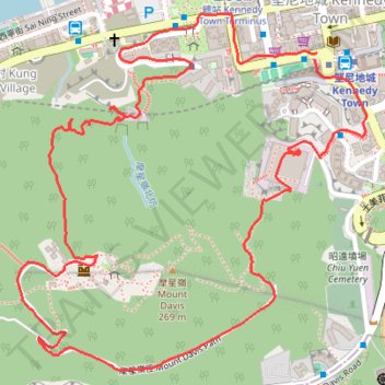
摩星嶺北右坑
Loop hike
- Distance: 2.5 mi
- Elevation gain: 284 m
- Maximum elevation: 239 m
- Elevation loss: 282 m
- Minimum elevation: 15 m
- Moving time: 56 m 56 s
- Moving speed: 2.7 mph
- Maximum speed: 20.1 mph
- Total time: 1 h 31 m
- Global speed: 1.7 mph
Interactive trail map
Trail profile
- Distance: 2.5 mi
- Elevation gain: 284 m
- Maximum elevation: 239 m
- Elevation loss: 282 m
- Minimum elevation: 15 m
- Moving time: 56 m 56 s
- Moving speed: 2.7 mph
- Maximum speed: 20.1 mph
- Total time: 1 h 31 m
- Global speed: 1.7 mph
About this trail
Name: 摩星嶺北右坑 trail, distance, elevation, map, profile, GPS track
Coordinates: 22.27487 114.12140 22.28228 114.12924
Other hiking, mountain biking, running and outdoor activity trails
Click on a trail to view its statistics, map and profile.
HK dino
China > Hong Kong > Hong Kong Island
Loop hike from Kennedy Town via Lung Fu Shan, High West, Victoria Peak, Pok Fu Lam Reservoir and Mount Davis in the Lung Fu Shan Country Park and the Pok Fu Lam Country Park. #Hiking #Loop #Nature #Mountain #Forest #Sea #Pacific #Ocean #Park
Distance: 15.2 mi • Elevation gain: 1,325 m • Maximum elevation: 529 m
Trail Planner Map
China > Hong Kong > Hong Kong Island
Distance: 12.6 mi • Elevation gain: 1,151 m • Maximum elevation: 423 m
摩星嶺北坑
China > Hong Kong > Hong Kong Island
Distance: 1.7 mi • Elevation gain: 244 m • Maximum elevation: 242 m
西寧坑
China > Hong Kong > Hong Kong Island
Hong Kong Island Hike
Distance: 2.3 mi • Elevation gain: 264 m • Maximum elevation: 213 m