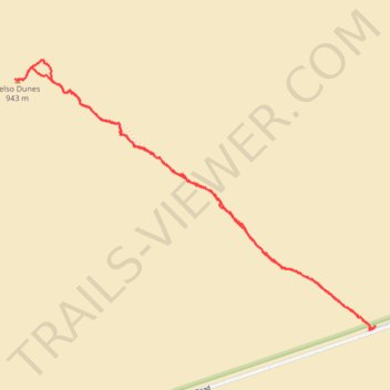
Kelso Dunes Trail
- Distance: 3.1 mi
- Elevation gain: 157 m
- Maximum elevation: 932 m
- Elevation loss: 157 m
- Minimum elevation: 787 m
- Moving time: 1 h 25 m
- Moving speed: 2.2 mph
- Maximum speed: 4.3 mph
- Total time: 1 h 59 m
- Global speed: 1.6 mph
Interactive trail map
Trail profile
- Distance: 3.1 mi
- Elevation gain: 157 m
- Maximum elevation: 932 m
- Elevation loss: 157 m
- Minimum elevation: 787 m
- Moving time: 1 h 25 m
- Moving speed: 2.2 mph
- Maximum speed: 4.3 mph
- Total time: 1 h 59 m
- Global speed: 1.6 mph
About this trail
Name: Kelso Dunes Trail trail, distance, elevation, map, profile, GPS track
Start: Kelso-Dunes Road, San Bernardino County, California, United States (34.89232 -115.69916)
End: Kelso-Dunes Road, San Bernardino County, California, United States (34.89230 -115.69918)
Coordinates: 34.89230 -115.71835 34.90430 -115.69884