Blockley 🔁 Snowshill
Blockley-Snowshill loop trailrun
- Distance: 15.5 mi
- Elevation gain: 500 m
- Maximum elevation: 317 m
- Elevation loss: 498 m
- Minimum elevation: 136 m
- Moving time: 2 h 33 m
- Moving speed: 6.1 mph
- Maximum speed: 10.0 mph
- Total time: 2 h 33 m
- Global speed: 6.1 mph
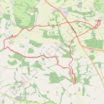
Interactive trail map
Trail profile
- Distance: 15.5 mi
- Elevation gain: 500 m
- Maximum elevation: 317 m
- Elevation loss: 498 m
- Minimum elevation: 136 m
- Moving time: 2 h 33 m
- Moving speed: 6.1 mph
- Maximum speed: 10.0 mph
- Total time: 2 h 33 m
- Global speed: 6.1 mph
About this trail
Name: Blockley 🔁 Snowshill trail, distance, elevation, map, profile, GPS track
Start: Blockley, Cotswold District, Gloucestershire, England, GL56 9BU, United Kingdom (52.01386 -1.76119)
End: Blockley, Cotswold District, Gloucestershire, England, GL56 9BU, United Kingdom (52.01383 -1.76167)
Coordinates: 51.96892 -1.86961 52.01387 -1.76015
Topography: Cotswold District topographic map, elevation, terrain
Other hiking, mountain biking, running and outdoor activity trails
Click on a trail to view its statistics, map and profile.
Broadway ➡️ Wood Stanway ➡️ Cutsdean ➡️ Broadway
United Kingdom > England > Worcestershire > Wychavon > Broadway
Distance: 15.2 mi • Elevation gain: 605 m • Maximum elevation: 304 m
Broadway ↗️ Snowshill ↘️ Stanton ➡️ Buckland
United Kingdom > England > Worcestershire > Wychavon > Broadway
Distance: 14.1 mi • Elevation gain: 706 m • Maximum elevation: 322 m