Little O'Malley Peak Trail in Chugach State Park
The Little O'Malley Peak Trail is a delightful adventure perfect for nature lovers! Starting from the Glen Alps Trailhead, you'll enjoy a gentle walk through lush landscapes, cross a charming boardwalk, and then tackle a thrilling climb to the summit, where panoramic views of Anchorage and the majestic Chugach Mountains await. This hike is not only a feast for the eyes but also a wonderful opportunity to spot wildlife and relish the serene beauty of Alaska. #Hiking #Mountain #Forest #Nature
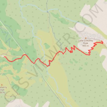
- Distance: 4.8 mi
- Elevation gain: 434 m
- Maximum elevation: 980 m
- Elevation loss: 433 m
- Minimum elevation: 612 m
- Moving time: 2 h 3 m
- Moving speed: 2.3 mph
- Maximum speed: 4.0 mph
- Total time: 2 h 51 m
- Global speed: 1.7 mph
Interactive trail map
Trail profile
- Distance: 4.8 mi
- Elevation gain: 434 m
- Maximum elevation: 980 m
- Elevation loss: 433 m
- Minimum elevation: 612 m
- Moving time: 2 h 3 m
- Moving speed: 2.3 mph
- Maximum speed: 4.0 mph
- Total time: 2 h 51 m
- Global speed: 1.7 mph
About this trail
Name: Little O'Malley Peak Trail in Chugach State Park trail, distance, elevation, map, profile, GPS track
Start: Powerline Access Trail #1, Anchorage, Alaska, United States (61.10347 -149.67910)
End: Powerline Access Trail #1, Anchorage, Alaska, United States (61.10343 -149.67922)
Coordinates: 61.10165 -149.67922 61.10648 -149.64064
Other hiking, mountain biking, running and outdoor activity trails
Click on a trail to view its statistics, map and profile.
Flattop Mountain via Blueberry Knoll Loop in Chugach State Park
United States > Alaska > Anchorage
Hiking the Flattop Mountain offers a satisfying adventure with stunning panoramic views. The trail, though short, is steep and can be quite challenging as you approach the summit, where some scrambling is required, making it both physically and technically engaging. Along the way, you'll enjoy the scenic…
Distance: 3.4 mi • Elevation gain: 406 m • Maximum elevation: 1,071 m