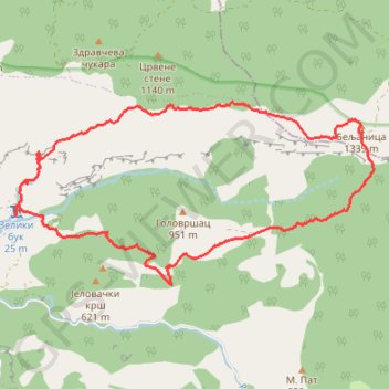
Beljanica kruzna ( Lisine-Tunelska pecina-vrh Beljanica - Ve...
- Distance: 9.8 mi
- Elevation gain: 1,158 m
- Maximum elevation: 1,335 m
- Elevation loss: 1,160 m
- Minimum elevation: 381 m
- Moving time: 5 h 4 m
- Moving speed: 1.9 mph
- Maximum speed: 35.5 mph
- Total time: 8 h 41 m
- Global speed: 1.1 mph
Interactive trail map
Trail profile
- Distance: 9.8 mi
- Elevation gain: 1,158 m
- Maximum elevation: 1,335 m
- Elevation loss: 1,160 m
- Minimum elevation: 381 m
- Moving time: 5 h 4 m
- Moving speed: 1.9 mph
- Maximum speed: 35.5 mph
- Total time: 8 h 41 m
- Global speed: 1.1 mph
About this trail
Name: Beljanica kruzna ( Lisine-Tunelska pecina-vrh Beljanica - Ve... trail, distance, elevation, map, profile, GPS track
Coordinates: 44.09159 21.63926 44.11451 21.70177
Other hiking, mountain biking, running and outdoor activity trails
Click on a trail to view its statistics, map and profile.
Beljanica
Serbia > Central Serbia > Pomoravlje Administrative District > Despotovac Municipality > Strmosten
Distance: 10.3 mi • Elevation gain: 1,041 m • Maximum elevation: 1,335 m
Beljanica: od Lisina, kroz tunelsku pećinu, Sokolica, Goveda...
Serbia > Central Serbia > Pomoravlje Administrative District > Despotovac Municipality > Strmosten
Distance: 9.5 mi • Elevation gain: 1,060 m • Maximum elevation: 1,335 m
2022_Yu
Slovenia > Ajdovščina > Žapuže
Distance: 1,526.9 mi • Elevation gain: 32,048 m • Maximum elevation: 1,950 m