Saint Louis Canyon Trail in Starved Rock State Park
The Saint Louis Canyon Trail offers hikers a captivating experience with its stunning waterfall and dramatic sandstone formations. As you traverse the well-marked path, you'll encounter a mix of dense forests and the sounds of cascading water, making it a refreshing escape into nature. The trail includes some steep sections and stairs, rewarding your efforts with breathtaking views and opportunities to explore unique geological features along the way. #Hiking #Canyon #Rock #Waterfall #Forest #Nature
- Distance: 2.4 mi
- Elevation gain: 85 m
- Maximum elevation: 182 m
- Elevation loss: 85 m
- Minimum elevation: 151 m
- Moving time: 1 h 14 m
- Moving speed: 1.9 mph
- Maximum speed: 4.0 mph
- Total time: 1 h 20 m
- Global speed: 1.8 mph
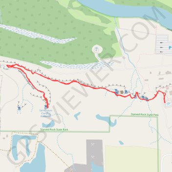
Interactive trail map
Trail profile
- Distance: 2.4 mi
- Elevation gain: 85 m
- Maximum elevation: 182 m
- Elevation loss: 85 m
- Minimum elevation: 151 m
- Moving time: 1 h 14 m
- Moving speed: 1.9 mph
- Maximum speed: 4.0 mph
- Total time: 1 h 20 m
- Global speed: 1.8 mph
About this trail
Name: Saint Louis Canyon Trail in Starved Rock State Park trail, distance, elevation, map, profile, GPS track
Start: East 875th Road, LaSalle County, Illinois, 61348, United States (41.31821 -88.99540)
End: East 875th Road, LaSalle County, Illinois, 61348, United States (41.31823 -88.99537)
Coordinates: 41.31791 -89.00899 41.32071 -88.99534