Depanne
- Distance: 6.5 mi
- Elevation gain: 41 m
- Maximum elevation: 12 m
- Elevation loss: 41 m
- Minimum elevation: -1 m
Interactive trail map
Trail profile
- Distance: 6.5 mi
- Elevation gain: 41 m
- Maximum elevation: 12 m
- Elevation loss: 41 m
- Minimum elevation: -1 m
About this trail
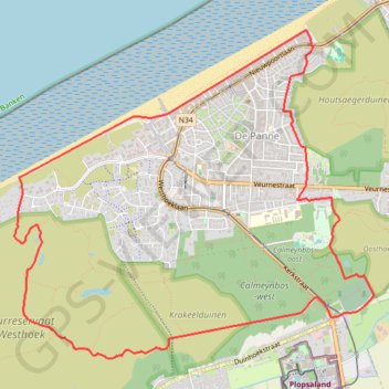
Name: Depanne trail, distance, elevation, map, profile, GPS track
Coordinates: 51.08298 2.56503 51.10635 2.60575
Other hiking, mountain biking, running and outdoor activity trails
Click on a trail to view its statistics, map and profile.
Peerdevisschers Walk 25 km Wandelclub Nieuwpoort 2025
Belgium > West Flanders > Veurne > Koksijde > Oostduinkerke
<p>Van Witte Burg, 8670 Oostduinkerke, België<br/> Naar Witte Burg, 8670 Oostduinkerke, België</p> <p>Routering Kortste - OSM, Wandelen - knooppunten, Manueel</p>
Distance: 15.5 mi • Elevation gain: 119 m • Maximum elevation: 24 m