Make a donation
Gear up for your next adventure:
As an Amazon Associate, this site earns from qualifying purchases at no extra cost to you.
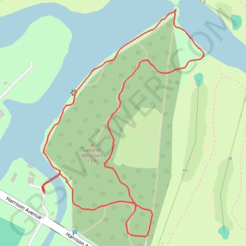
Couturie Forest Loop in New Orleans City Park
The Couturie Forest Loop offers a tranquil escape through a variety of lush ecosystems. As you follow the trail, you'll encounter scenic lagoons, shaded areas beneath native trees, and a rich diversity of wildlife, including excellent birdwatching opportunities. Highlights of the route include the peaceful forest atmosphere and the chance to summit "Laborde Mountain," the highest natural point in the city, providing a rare elevated view amidst this urban oasis. #Hiking #Loop #Lake #Forest #Nature
- Distance: 1.1 mi
- Elevation gain: 2 m
- Maximum elevation: 4 m
- Elevation loss: 2 m
- Minimum elevation: 2 m
- Moving time: 22 m 22 s
- Moving speed: 3.0 mph
- Maximum speed: 6.5 mph
- Total time: 22 m 22 s
- Global speed: 3.0 mph
Interactive trail map
Make a donation
Gear up for your next adventure:
As an Amazon Associate, this site earns from qualifying purchases at no extra cost to you.
Trail profile
- Distance: 1.1 mi
- Elevation gain: 2 m
- Maximum elevation: 4 m
- Elevation loss: 2 m
- Minimum elevation: 2 m
- Moving time: 22 m 22 s
- Moving speed: 3.0 mph
- Maximum speed: 6.5 mph
- Total time: 22 m 22 s
- Global speed: 3.0 mph
Make a donation
Gear up for your next adventure:
As an Amazon Associate, this site earns from qualifying purchases at no extra cost to you.
About this trail
Name: Couturie Forest Loop in New Orleans City Park trail, distance, elevation, map, profile, GPS track
Coordinates: 30.00260 -90.09507 30.00716 -90.09133
Make a donation
Gear up for your next adventure:
As an Amazon Associate, this site earns from qualifying purchases at no extra cost to you.