Thank you for supporting this site ❤️
Make a donation
Make a donation
Gear up for your next adventure:
As an Amazon Associate, this site earns from qualifying purchases at no extra cost to you.
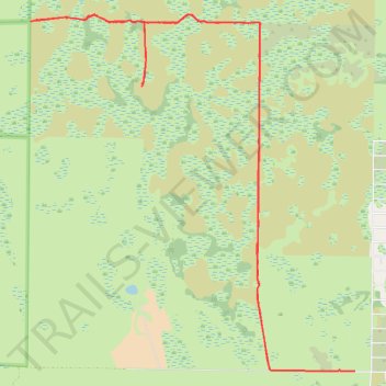
Kissimmee Bend State Forest and access
- Distance: 12.6 mi
- Elevation gain: 22 m
- Maximum elevation: 21 m
- Elevation loss: 22 m
- Minimum elevation: 17 m
- Moving time: 1 h 37 m
- Moving speed: 7.7 mph
- Maximum speed: 17.0 mph
- Total time: 2 h 52 m
- Global speed: 4.4 mph
Interactive trail map
Thank you for supporting this site ❤️
Make a donation
Make a donation
Gear up for your next adventure:
As an Amazon Associate, this site earns from qualifying purchases at no extra cost to you.
Trail profile
- Distance: 12.6 mi
- Elevation gain: 22 m
- Maximum elevation: 21 m
- Elevation loss: 22 m
- Minimum elevation: 17 m
- Moving time: 1 h 37 m
- Moving speed: 7.7 mph
- Maximum speed: 17.0 mph
- Total time: 2 h 52 m
- Global speed: 4.4 mph
Thank you for supporting this site ❤️
Make a donation
Make a donation
Gear up for your next adventure:
As an Amazon Associate, this site earns from qualifying purchases at no extra cost to you.
About this trail
Name: Kissimmee Bend State Forest and access trail, distance, elevation, map, profile, GPS track
Start: 22839, Northwest 256th Street, Okeechobee County, Florida, 34972, United States (27.48016 -81.05910)
End: Okeechobee County, Florida, United States (27.48047 -81.07152)
Coordinates: 27.48013 -81.10618 27.52602 -81.05910
Thank you for supporting this site ❤️
Make a donation
Make a donation
Gear up for your next adventure:
As an Amazon Associate, this site earns from qualifying purchases at no extra cost to you.