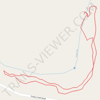
Turkey Creek
- Distance: 0.4 mi
- Elevation gain: 19 m
- Maximum elevation: 182 m
- Elevation loss: 19 m
- Minimum elevation: 169 m
- Moving time: 14 m 26 s
- Moving speed: 1.7 mph
- Maximum speed: 2.7 mph
- Total time: 18 m 19 s
- Global speed: 1.3 mph
Interactive trail map
Trail profile
- Distance: 0.4 mi
- Elevation gain: 19 m
- Maximum elevation: 182 m
- Elevation loss: 19 m
- Minimum elevation: 169 m
- Moving time: 14 m 26 s
- Moving speed: 1.7 mph
- Maximum speed: 2.7 mph
- Total time: 18 m 19 s
- Global speed: 1.3 mph
About this trail
Name: Turkey Creek trail, distance, elevation, map, profile, GPS track
Start: Boy Scout Trail, Pinson, Jefferson County, Alabama, 35126, United States (33.70341 -86.69707)
End: Boy Scout Trail, Pinson, Jefferson County, Alabama, 35126, United States (33.70340 -86.69714)
Coordinates: 33.70217 -86.69863 33.70353 -86.69691