Lost Smith Trail
- Distance: 5.3 mi
- Elevation gain: 506 m
- Maximum elevation: 950 m
- Elevation loss: 506 m
- Minimum elevation: 459 m
- Moving time: 2 h 39 m
- Moving speed: 2.0 mph
- Maximum speed: 7.8 mph
- Total time: 3 h 52 m
- Global speed: 1.4 mph
Interactive trail map
Trail profile
- Distance: 5.3 mi
- Elevation gain: 506 m
- Maximum elevation: 950 m
- Elevation loss: 506 m
- Minimum elevation: 459 m
- Moving time: 2 h 39 m
- Moving speed: 2.0 mph
- Maximum speed: 7.8 mph
- Total time: 3 h 52 m
- Global speed: 1.4 mph
About this trail
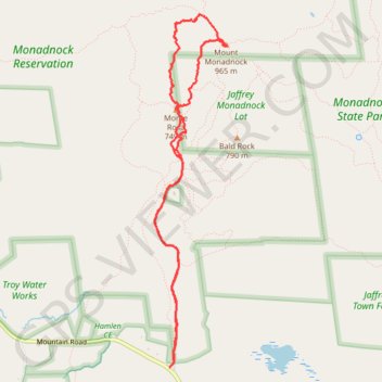
Name: Lost Smith Trail trail, distance, elevation, map, profile, GPS track
Coordinates: 42.83520 -72.11598 42.86388 -72.10796
Other hiking, mountain biking, running and outdoor activity trails
Click on a trail to view its statistics, map and profile.
Mount Monadnock Loop via White Dot Trail and White Cross Trail in Monadnock State Park
United States > New Hampshire > Cheshire County > Jaffrey
The Mount Monadnock Loop offers a diverse hiking experience with a combination of challenging rock scrambles and scenic views. The ascent via the White Dot Trail is steep and demanding, with plenty of rocky terrain, while the White Cross Trail provides a somewhat gentler but still rugged descent, featuring…
Distance: 4.0 mi • Elevation gain: 529 m • Maximum elevation: 948 m
Mount Monadnock and Monte Rosa loop via Smith Trail
United States > New Hampshire > Cheshire County > Jaffrey
Distance: 5.2 mi • Elevation gain: 517 m • Maximum elevation: 950 m
Bald Rock, Paradise Valley trail and others in the Monadnock State Park
United States > New Hampshire > Cheshire County > Jaffrey
Distance: 4.7 mi • Elevation gain: 550 m • Maximum elevation: 890 m
Lost Paradise Valley Loop Trail
United States > New Hampshire > Cheshire County > Jaffrey
Distance: 4.8 mi • Elevation gain: 550 m • Maximum elevation: 890 m