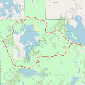
Crooked Lake Loop Trail in Pinckney Recreation Area
The Crooked Lake Loop Trail offers hikers a well-rounded outdoor experience within the scenic Pinckney Recreation Area. As it weaves through lush hardwood forests, hikers will encounter wetlands and open fields, with tranquil views of Crooked Lake. The relatively moderate trail allows ample opportunities for birdwatching, wildlife spotting, and enjoying the natural beauty of the area, especially in the fall when the vibrant colors enhance the landscape. #Hiking #Loop #Lake #Forest #Nature
- Distance: 4.4 mi
- Elevation gain: 106 m
- Maximum elevation: 298 m
- Elevation loss: 101 m
- Minimum elevation: 262 m
- Moving time: 1 h 43 m
- Moving speed: 2.6 mph
- Maximum speed: 6.2 mph
- Total time: 1 h 45 m
- Global speed: 2.5 mph
Interactive trail map
Trail profile
- Distance: 4.4 mi
- Elevation gain: 106 m
- Maximum elevation: 298 m
- Elevation loss: 101 m
- Minimum elevation: 262 m
- Moving time: 1 h 43 m
- Moving speed: 2.6 mph
- Maximum speed: 6.2 mph
- Total time: 1 h 45 m
- Global speed: 2.5 mph
About this trail
Name: Crooked Lake Loop Trail in Pinckney Recreation Area trail, distance, elevation, map, profile, GPS track
Start: Potawatomi Trail, Dexter Township, Washtenaw County, Michigan, United States (42.41754 -83.96461)
End: Potawatomi Trail, Dexter Township, Washtenaw County, Michigan, United States (42.41696 -83.96391)
Coordinates: 42.41125 -83.99180 42.42483 -83.96389