Thank you for supporting this site ❤️
Make a donation
Make a donation
Gear up for your next adventure:
As an Amazon Associate, this site earns from qualifying purchases at no extra cost to you.
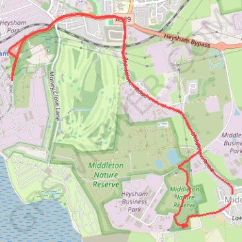
Middleton Road & pump track
Bicycle
- Distance: 4.6 mi
- Elevation gain: 52 m
- Maximum elevation: 21 m
- Elevation loss: 53 m
- Minimum elevation: 9 m
- Moving time: 21 m 2 s
- Moving speed: 13.2 mph
- Maximum speed: 22.9 mph
- Total time: 8 h 54 m
- Global speed: 0.5 mph
Interactive trail map
Thank you for supporting this site ❤️
Make a donation
Make a donation
Gear up for your next adventure:
As an Amazon Associate, this site earns from qualifying purchases at no extra cost to you.
Trail profile
- Distance: 4.6 mi
- Elevation gain: 52 m
- Maximum elevation: 21 m
- Elevation loss: 53 m
- Minimum elevation: 9 m
- Moving time: 21 m 2 s
- Moving speed: 13.2 mph
- Maximum speed: 22.9 mph
- Total time: 8 h 54 m
- Global speed: 0.5 mph
Thank you for supporting this site ❤️
Make a donation
Make a donation
Gear up for your next adventure:
As an Amazon Associate, this site earns from qualifying purchases at no extra cost to you.
About this trail
Name: Middleton Road & pump track trail, distance, elevation, map, profile, GPS track
Start: 8, Carr Lane, Middleton, Lancaster, Lancashire, England, LA3 3JX, United Kingdom (54.02187 -2.88186)
Coordinates: 54.01933 -2.91093 54.03567 -2.88183
Topography: Lancaster topographic map, elevation, terrain
Thank you for supporting this site ❤️
Make a donation
Make a donation
Gear up for your next adventure:
As an Amazon Associate, this site earns from qualifying purchases at no extra cost to you.