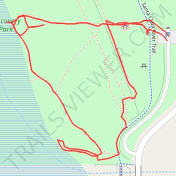
Discovery Park
- Distance: 0.5 mi
- Elevation gain: 4 m
- Maximum elevation: 407 m
- Elevation loss: 4 m
- Minimum elevation: 403 m
- Moving time: 18 m 23 s
- Moving speed: 1.7 mph
- Maximum speed: 3.7 mph
- Total time: 20 m 45 s
- Global speed: 1.5 mph
Interactive trail map
Trail profile
- Distance: 0.5 mi
- Elevation gain: 4 m
- Maximum elevation: 407 m
- Elevation loss: 4 m
- Minimum elevation: 403 m
- Moving time: 18 m 23 s
- Moving speed: 1.7 mph
- Maximum speed: 3.7 mph
- Total time: 20 m 45 s
- Global speed: 1.5 mph
About this trail
Name: Discovery Park trail, distance, elevation, map, profile, GPS track
Coordinates: 34.42357 -118.48284 34.42493 -118.48099
Other hiking, mountain biking, running and outdoor activity trails
Click on a trail to view its statistics, map and profile.
Discovery Park Loop Walk
United States > California > Los Angeles County > Santa Clarita
Distance: 0.9 mi • Elevation gain: 7 m • Maximum elevation: 407 m