Fish Creek Provincial Park Loop Walk
- Distance: 3.5 mi
- Elevation gain: 16 m
- Maximum elevation: 1,015 m
- Elevation loss: 16 m
- Minimum elevation: 1,004 m
- Moving time: 1 h 14 m
- Moving speed: 2.8 mph
- Maximum speed: 6.4 mph
- Total time: 1 h 24 m
- Global speed: 2.5 mph
Interactive trail map
Trail profile
- Distance: 3.5 mi
- Elevation gain: 16 m
- Maximum elevation: 1,015 m
- Elevation loss: 16 m
- Minimum elevation: 1,004 m
- Moving time: 1 h 14 m
- Moving speed: 2.8 mph
- Maximum speed: 6.4 mph
- Total time: 1 h 24 m
- Global speed: 2.5 mph
About this trail
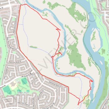
Name: Fish Creek Provincial Park Loop Walk trail, distance, elevation, map, profile, GPS track
Start: 153 Avenue SE, Fish Creek Park, Calgary, Alberta, T2J 5G3, Canada (50.91856 -113.99396)
End: 153 Avenue SE, Fish Creek Park, Calgary, Alberta, T2J 5G3, Canada (50.91842 -113.99395)
Coordinates: 50.91842 -114.00867 50.93352 -113.99054