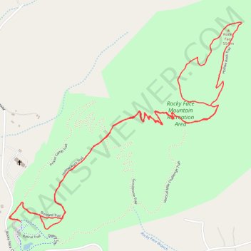
Rocky Face Mountain via Hollow Rock Trail
- Distance: 3.4 mi
- Elevation gain: 198 m
- Maximum elevation: 538 m
- Elevation loss: 198 m
- Minimum elevation: 349 m
- Moving time: 47 m 36 s
- Moving speed: 4.3 mph
- Maximum speed: 6.7 mph
- Total time: 47 m 36 s
- Global speed: 4.3 mph
Interactive trail map
Trail profile
- Distance: 3.4 mi
- Elevation gain: 198 m
- Maximum elevation: 538 m
- Elevation loss: 198 m
- Minimum elevation: 349 m
- Moving time: 47 m 36 s
- Moving speed: 4.3 mph
- Maximum speed: 6.7 mph
- Total time: 47 m 36 s
- Global speed: 4.3 mph
About this trail
Name: Rocky Face Mountain via Hollow Rock Trail trail, distance, elevation, map, profile, GPS track
Start: Quarry Trail, Alexander County, North Carolina, United States (35.96366 -81.12035)
End: Quarry Trail, Alexander County, North Carolina, United States (35.96366 -81.12036)
Coordinates: 35.96332 -81.12097 35.97271 -81.10794