Thank you for supporting this site ❤️
Make a donation
Make a donation
Gear up for your next adventure:
As an Amazon Associate, this site earns from qualifying purchases at no extra cost to you.
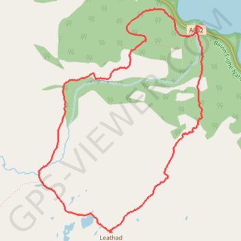
Beinn Eighe Mountain Trail
- Distance: 3.9 mi
- Elevation gain: 553 m
- Maximum elevation: 555 m
- Elevation loss: 551 m
- Minimum elevation: 14 m
- Moving time: 2 h 41 m
- Moving speed: 1.5 mph
- Maximum speed: 3.5 mph
- Total time: 4 h 14 m
- Global speed: 0.9 mph
Interactive trail map
Thank you for supporting this site ❤️
Make a donation
Make a donation
Gear up for your next adventure:
As an Amazon Associate, this site earns from qualifying purchases at no extra cost to you.
Trail profile
- Distance: 3.9 mi
- Elevation gain: 553 m
- Maximum elevation: 555 m
- Elevation loss: 551 m
- Minimum elevation: 14 m
- Moving time: 2 h 41 m
- Moving speed: 1.5 mph
- Maximum speed: 3.5 mph
- Total time: 4 h 14 m
- Global speed: 0.9 mph
Thank you for supporting this site ❤️
Make a donation
Make a donation
Gear up for your next adventure:
As an Amazon Associate, this site earns from qualifying purchases at no extra cost to you.
About this trail
Name: Beinn Eighe Mountain Trail trail, distance, elevation, map, profile, GPS track
Coordinates: 57.61504 -5.37182 57.63206 -5.34841
Topography: Highland topographic map, elevation, terrain
Thank you for supporting this site ❤️
Make a donation
Make a donation
Gear up for your next adventure:
As an Amazon Associate, this site earns from qualifying purchases at no extra cost to you.