Make a donation
Gear up for your next adventure:
As an Amazon Associate, this site earns from qualifying purchases at no extra cost to you.
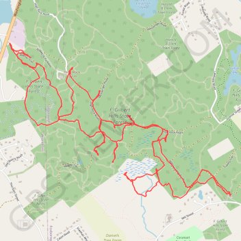
My Warner Trail hike in F. Gilbert Hills State Forest
- Distance: 8.5 mi
- Elevation gain: 219 m
- Maximum elevation: 134 m
- Elevation loss: 218 m
- Minimum elevation: 60 m
- Moving time: 4 h 8 m
- Moving speed: 2.1 mph
- Maximum speed: 3.6 mph
- Total time: 5 h 23 m
- Global speed: 1.6 mph
Interactive trail map
Make a donation
Gear up for your next adventure:
As an Amazon Associate, this site earns from qualifying purchases at no extra cost to you.
Trail profile
- Distance: 8.5 mi
- Elevation gain: 219 m
- Maximum elevation: 134 m
- Elevation loss: 218 m
- Minimum elevation: 60 m
- Moving time: 4 h 8 m
- Moving speed: 2.1 mph
- Maximum speed: 3.6 mph
- Total time: 5 h 23 m
- Global speed: 1.6 mph
Make a donation
Gear up for your next adventure:
As an Amazon Associate, this site earns from qualifying purchases at no extra cost to you.
About this trail
Name: My Warner Trail hike in F. Gilbert Hills State Forest trail, distance, elevation, map, profile, GPS track
Coordinates: 42.04966 -71.29390 42.06399 -71.26614
Make a donation
Gear up for your next adventure:
As an Amazon Associate, this site earns from qualifying purchases at no extra cost to you.
Other hiking, mountain biking, running and outdoor activity trails
Click on a trail to view its statistics, map and profile.
Cambridge - Providence Express
United States > Massachusetts > Middlesex County > Cambridge
Alewife -> Providence
Distance: 63.2 mi • Elevation gain: 961 m • Maximum elevation: 107 m
F. Gilbert Hills State Forest
United States > Massachusetts > Norfolk County > Foxborough > North Foxboro
Mountain Bike F. Gilbert Hills State Forest
Distance: 19.1 mi • Elevation gain: 268 m • Maximum elevation: 103 m
Dedham-Providence-Dedham
United States > Massachusetts > Norfolk County > Dedham
Distance: 126.0 mi • Elevation gain: 1,811 m • Maximum elevation: 167 m