Balmoral Estate
Mountain Bike Ride #UK #Aberdeenshire #BalmoralEstate
- Distance: 11.6 mi
- Elevation gain: 301 m
- Maximum elevation: 437 m
- Elevation loss: 305 m
- Minimum elevation: 269 m
- Moving time: 1 h 39 m
- Moving speed: 7.0 mph
- Maximum speed: 20.8 mph
- Total time: 2 h 5 m
- Global speed: 5.5 mph
Interactive trail map
Trail profile
- Distance: 11.6 mi
- Elevation gain: 301 m
- Maximum elevation: 437 m
- Elevation loss: 305 m
- Minimum elevation: 269 m
- Moving time: 1 h 39 m
- Moving speed: 7.0 mph
- Maximum speed: 20.8 mph
- Total time: 2 h 5 m
- Global speed: 5.5 mph
About this trail
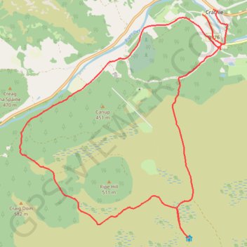
Name: Balmoral Estate trail, distance, elevation, map, profile, GPS track
End: B976, Crathie, Aberdeenshire, Scotland, AB35 5TL, United Kingdom (57.03999 -3.21525)
Coordinates: 56.99511 -3.28508 57.03999 -3.21018
Topography: Aberdeenshire topographic map, elevation, terrain
Other hiking, mountain biking, running and outdoor activity trails
Click on a trail to view its statistics, map and profile.
Balmoral Castle
United Kingdom > Scotland > Aberdeenshire > Crathie
Distance: 6.3 mi • Elevation gain: 290 m • Maximum elevation: 436 m