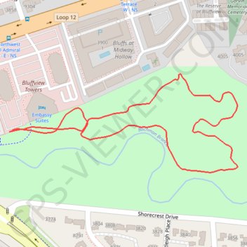
Bachman Greenbelt Trail
Bachman Greenbelt, Nature Trail, Loop
- Distance: 0.9 mi
- Elevation gain: 9 m
- Maximum elevation: 147 m
- Elevation loss: 8 m
- Minimum elevation: 140 m
- Moving time: 21 m 4 s
- Moving speed: 2.7 mph
- Maximum speed: 3.3 mph
- Total time: 21 m 4 s
- Global speed: 2.7 mph
Interactive trail map
Trail profile
- Distance: 0.9 mi
- Elevation gain: 9 m
- Maximum elevation: 147 m
- Elevation loss: 8 m
- Minimum elevation: 140 m
- Moving time: 21 m 4 s
- Moving speed: 2.7 mph
- Maximum speed: 3.3 mph
- Total time: 21 m 4 s
- Global speed: 2.7 mph
About this trail
Name: Bachman Greenbelt Trail trail, distance, elevation, map, profile, GPS track
Start: Lemmon Avenue, Dallas, Dallas County, Texas, 75209, United States (32.86039 -96.85056)
End: Lemmon Avenue, Dallas, Dallas County, Texas, 75209, United States (32.86042 -96.85049)
Coordinates: 32.85961 -96.85056 32.86148 -96.84541