Thank you for supporting this site ❤️
Make a donation
Make a donation
Gear up for your next adventure:
As an Amazon Associate, this site earns from qualifying purchases at no extra cost to you.
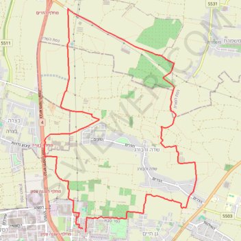
Route from 32.195890N, 34.891846E to סוסנובסקי
- Distance: 9.5 mi
- Elevation gain: 137 m
- Maximum elevation: 75 m
- Elevation loss: 137 m
- Minimum elevation: 26 m
Interactive trail map
Thank you for supporting this site ❤️
Make a donation
Make a donation
Gear up for your next adventure:
As an Amazon Associate, this site earns from qualifying purchases at no extra cost to you.
Trail profile
- Distance: 9.5 mi
- Elevation gain: 137 m
- Maximum elevation: 75 m
- Elevation loss: 137 m
- Minimum elevation: 26 m
Thank you for supporting this site ❤️
Make a donation
Make a donation
Gear up for your next adventure:
As an Amazon Associate, this site earns from qualifying purchases at no extra cost to you.
About this trail
Name: Route from 32.195890N, 34.891846E to סוסנובסקי trail, distance, elevation, map, profile, GPS track
Coordinates: 32.19531 34.88413 32.23338 34.91478
Thank you for supporting this site ❤️
Make a donation
Make a donation
Gear up for your next adventure:
As an Amazon Associate, this site earns from qualifying purchases at no extra cost to you.